Showing posts with label oregon. Show all posts

4/22/2013

Hiking Ramona Falls

If there is one thing our little Shiba loves it's a good hike. Last summer we took her up to the slopes of Mt. Hood to a place called Ramona Falls for a hike that was not only exhausting but beautiful.

Misaki always gets a little excited when we put her chestplate harness on her - and it's not because of the harness. She actually hates the harness, but she knows it means we are heading out to a real hike and not just a quick jaunt around the neighborhood.

This jaunt started early on a Saturday and it turned out to be not that great of a day. The clouds were low and it was a bit chilly, but we figured a 7-mile hike with a 1,000-foot elevation change would take care of a little chill.

Parking at the trailhead is a long ways off the beaten path. The exact route is detailed here, but basically you take Highway 26 to Zigzag, take a few turns, drive down some worn and poorly maintained roads, and you end up here:
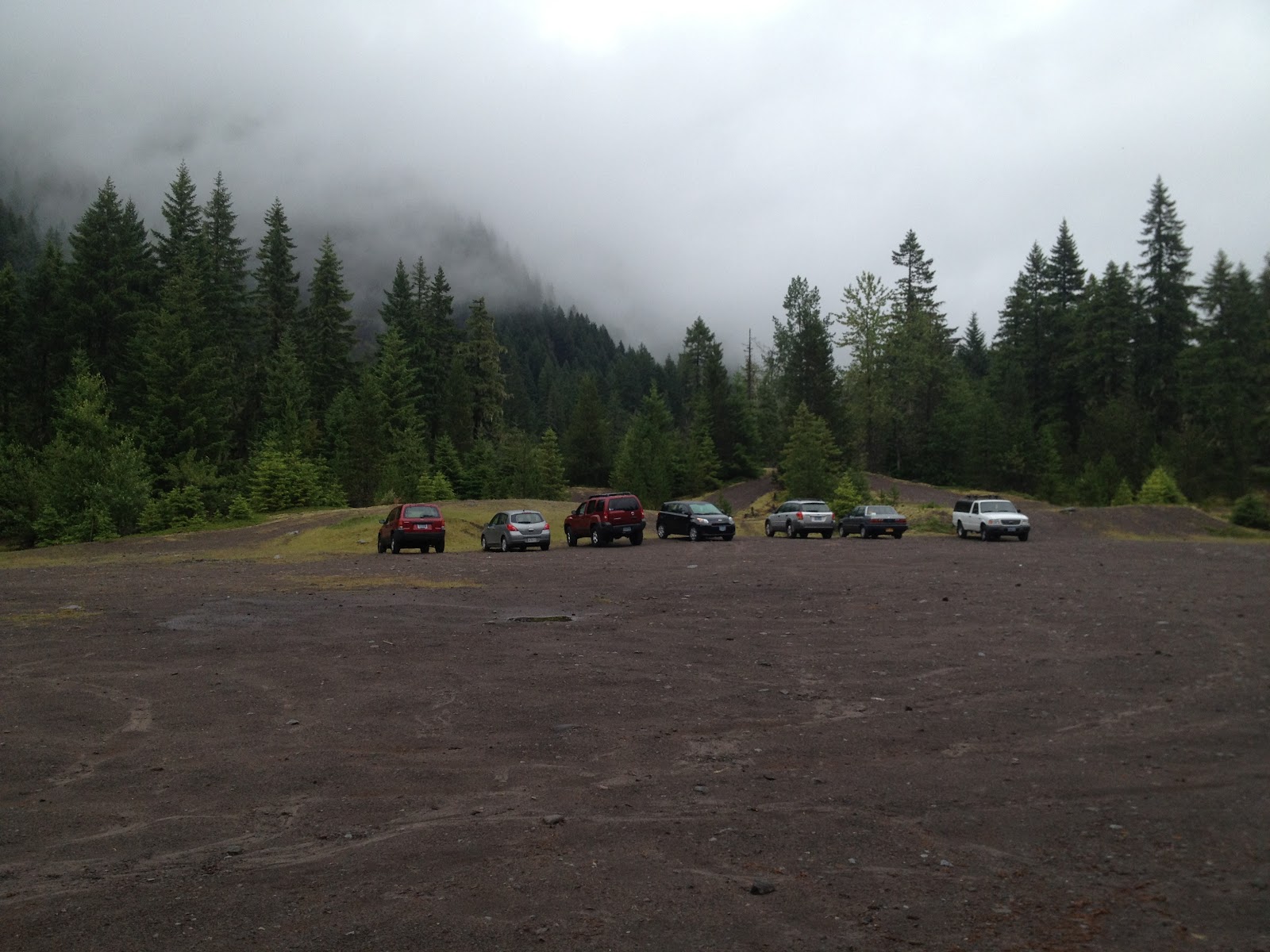

We got there pretty early (which means by 10am or so, since it's quite a drive from west Portland) and weren't sure we were in the right place. All of the references we looked at talked about how popular the spot was and how to find extra parking spots if the area was full. As you can see, we didn't have any problems. Maybe it was the weather, but honestly this doesn't seem like a place to decide to go on a whim. You have to plan for this hike to a certain extent, so while weather could be a factor I find it hard to believe people wake up on a nice day and just decide to head out here on a whim. This meant the trail wouldn't be busy though, so we liked that.


The trail follows the Sandy River for a while on a moderate slope. The landscape is pretty in the way nature's power can be pretty; this entire area was overrun with flooding just a couple years ago, washing out homes and roads, and the evidence of that destruction is everywhere.


After while you get to a bridge across the small but powerful river. There is no handrail and the "bridge" is narrow, only a few feet over the rushing water. Misaki surprised us both by jumping right up and walking across like it was no big deal. Honestly, I thought I might have to carry her. That's our pup - always keeping us on our toes.


The trail twists and turns through the forest and moss-covered rocks and dead trees cover the landscape. It's pretty, with every shade of green you can possibly imagine.


Then the uphill rise begins and it seems like it's never going to end. The rise isn't at any time too steep, it's just  constant. At times the river side of the narrow trail is basically far drop to the water and I was keeping a close watch on Misaki, although if anyone was going to slip it was probably me and not the dog.

She likes to freak us out, too. After Wifey and I spent some time talking about how easily you could just disappear out here - and my writer mind started down the path of a horror story - Misaki stopped at one point, staring into the woods. She even barked once, like there was something out there. Wifey and I looked as best as our weak human eyes could manage, but we have no idea what she saw. Bear? Cougar? No idea.

After the major climbs in the trail it switches back a few times through the woods, away from the river. The sound of rushing water teases you, getting louder and louder as you continue. Then, seemingly without warning, you step around a corner and you see this. (Please, click again on the picture. It's impossible to do this justice, but make it as big as you can.)


There she is, Ramona Falls in all her glory. You really have to spend some time here in order to get a true feeling for how magnificent this waterfall is, to see it from all the angles. And check out this bridge crossing the creek flowing from the waterfall.


Given how far from car access you are it's obvious it's built from the area's trees by necessity. It's very, very sturdy. I'd hate to have had to carry the chainsaw all the way in to build this with.

We had our lunch here, which consists of standing around and holding your food because, well, you are in the middle of the forest and there is no seating. It's also really loud, so it's not really the place to linger for a conversation or hang out with a book, so it's time to get back on the trail. You have two choices. You can either turn around and go back the way you came, or continue on down the path, which will eventually go far, far away or loop back to the trail you came in on near where you crossed the river (your choice).


We elected to try out the loop. This follows Ramona Creek all the way to the Sandy River. At points it runs along a gigantic rock wall that seems to just appear out of nowhere and is riddled with thin waterfalls. We crossed back and forth across the creek a few times, once on this magnificent bridge. This one seemed to be brand new.


To the right of it was an old one, battered and broken from many winters and floods.


We followed this trail for awhile and eventually reached the Sandy River, but not where we could actually cross it. Apparently we missed a turn. However, at this exact point were a few people crossing the river on a fallen tree. That didn't look safe at all but they didn't seem to be in any trouble. We turned back and apparently those people made it just fine, because we never saw anything on the news about missing hikers on Mt. Hood. At least not that week.

After we turned around we walked a short distance and ran into this written in the dirt and pine needles on the ground.


How handy! Apparently we weren't the only ones who missed a turn.

On the way back, after we crossed the same bridge over the Sandy River, we came upon some moss-covered boulders the size of a car. I picked up our cute little pup and put her up on top of the boulder, about six feet off the ground. I wasn't sure what she would do, but she seemed pretty pleased with her perch above her human servants. She calmly sat down on the rock, looking down at us as it to say, "Finally you know your place." We had to take some pictures and this one might be my favorite of her ever.


Misaki continues to amaze me. By the time we got back to the parking lot Wifey and I were dragging. That hike was exhausting, testing not only muscles but stamina. Despite packing plenty of food and water we just wanted to collapse on a couch. But Misaki? Not her. I swear she got stronger and stronger, picking up the pace the more miles we put behind us. We usually let her set the pace anyway, since it's faster than what we might set on our own (we joke that she's our trainer, pushing us more than we would push ourselves, and give her credit for keeping us in line), but we almost never see her out of breath.

After over seven miles of hiking, 1,000 feet up and down, she was in the parking lot with a great big grin on her face, wondering where we were going next. I should also point out that she's nine years old, which is something around 60 in dog years. I hope like hell when I'm 60 I'm in at least half as good of shape as Misaki is now.

Portlanders, get out of the city and check out this waterfall because it's not to be missed. Bring your dog, too, but as always, Misaki prefers it if your dog is on leash as she always is.

12/16/2012

Touch Portland's Water!

I was born in Portland, raised in Portland, lived my whole life in the Portland area (apart from my time at the University of Oregon), but I had never been to Mount Tabor Park until this past summer. Considering it dominates the landscape of the southeastern part of the city, that's quite an accomplishment.

Mount Tabor is not a mountain; it's a long dormant cinder cone, a relic of a volcanic eruption centuries ago, and named after a city in Israel. The park has hiking trails, tennis courts, basketball courts, picnic areas and fantastic vistas in all directions as one of Portland's highest points. When I was growing up it wasn't exactly known as very family friendly (probably why I had never been there), but these days - at least during daylight - families gather, lovers walk hand-in-hand and dogs are exercised by the dozens on the city's nicest days.

Also, the park is home to many of the reservoirs supplying drinking water to the City of Portland.


To me, it's a little odd. I mean, a person can literally walk right up to the reservoir (at the fence in the above picture), put their hand through the bars, and do whatever they want. Sure, the water is filtered and purified somewhere between these large pools and your faucet, but still.


And, as you can clearly see, they are completely open to weather and wildlife.


They do provide a nice backdrop for pictures. Even Misaki was impressed.

And yes, there are serious repercussions if anyone is caught messing with the pools. Presumably there is video surveillance as well.


Personally, I think there could be a little more prevention in place. These fences could be further back from the edge of the water, for one.


But hey, that's just me. The water at our house does not come from the City of Portland, but presumably it works out for them.

One of the reservoirs was empty because it was being cleaned and having some repairs done. These pictures do a poor job of really providing reference points for size - they are truly gigantic. Bigger in length and width than a football field, that iron fence is about eight feet high. You can also see the normal water line in this picture below, a few feet below the fence.


Here's a pic attempting to get the entire space. Doesn't that look like something you want to drink out of?


Drinking water aside, the park is a lot of fun and good exercise for people and their canines. And while the park is a fairly steep hill, the trails have been created so people can casually wind their way in circles to the top.

Or, if you are like us, you can simply take the stairs straight up.


The view from the top of the park probably isn't as good as it was 30-40 years ago because the evergreens continue to grow (not that I want to stand in their way). Still, on a nice day, a Shiba can see for miles. So can her humans.


It's a great place for a some exercise and we've been back a couple times since our initial visit.

Pro tips:

On nice days get there early. The parking lot fills up by noon.

Bring sunscreen on nice days because while there are plenty of trees all of the trails near the reservoirs are in open spaces.

Dogs on leash only. As it should be.

There are plenty of restaurants in the area to grab a bite. At the northeast corner of the park is Misaki's favorite, Steve's Cheese. At the east side is all the restaurants on Hawthorne. To the west side is The Country Cat for all meals, Bi-Partisan Cafe for coffee, pie and snacks, and Tanuki for dinner.

8/17/2012

Hiking Mirror Lake

Mirror Lake is one of those places we've driven by many, many times but never stopped at, usually for good reason because we are on our way to somewhere else.

We were missing out.

The access to the trail is just after civilization ends on Highway 26 east of Portland. The highway says goodbye to Welches, narrows to two lanes, and heads through some forest before widening to four lanes again and starting towards Government Camp. Off to the right the land drops steeply into a valley for awhile, but then you go around a curve and suddenly that same side of the street has a steep hill. Usually here you will see a mess of cars parked with no real signs - this is where you park to head to Mirror Lake.

This hike is a little over three miles round trip and is generally referred to as "easy." To be honest, calling this easy is a bunch of crap. Easy is walking on flat sidewalks. This hike involves steep hills and uneven surfaces, so to call it anything less than moderate is plain wrong.

Most of the hike is uphill over a myriad of switchbacks, crossing a creek or two on narrow bridges, over ground riddled with stumps and rocks. Going up the terrain isn't a big deal, but going down following a crazy little Shiba named Misaki who apparently would rather run it's kind of dangerous. Be careful! (As always, click the pictures to see larger versions.)

One example of a switchback.

I wanted to get a picture down the hill, but the trees were too dense and they didn't really turn out.

There is a rock slide that the trail switches back and forth across about three or four times on the way; Misaki was quite pleased with herself for conquering the boulders.

Misaki is quite proud of herself.

Here's a pic of one of the bridges, this one just before the trail splits to go around the lake. Misaki continues to amaze me at how fearless she is. The creek rushed underneath, but she took a measure of what it would take to hop onto the narrow bridge and just did it. Most dogs, especially smaller ones, would hesitate, but not her.

Fearless pup.

Guess who was the first one to see the lake?

Zen.

And what did she see, a little over a mile and a half into our hike? It's breathtaking, really. They don't call it Mirror Lake for nothin'.

No words.

Wifey and I had packed a lunch, so we sat on the rocks at the water's edge. We tried to enjoy the quiet, but it was shattered by a bunch of out of control kids with no sense of personal space.

One interesting note: You can make this a longer hike. Turning away from Mt. Hood, if you look up to the right there is a ridge - Tom Dick and Harry Mountain (really) - far into the distance (another four miles each way, I think). Someday, when I'm better prepared, that would be a fun (you know, if by fun I mean exhausting, mentally draining, and likely to induce massive hamstring cramps) hike to do. I can just imagine the amazing pictures one could take.

We had some chipmunks hang out with us for lunch, as well as this little guy and some birds we'd never seen before.

Our dining companion.

Misaki generally leaves the wildlife alone, but I was wondering if maybe she was going to go after some of the fish darting around in the shallows.

Looking for noms.

We had a great time. It's a great workout (moderate, not easy - I want to see their definition of easy) and not too far away. However, get their early, especially on a nice day on the weekend because that parking area can fill up and you don't want to be forced to park on the very edge of Highway 26 as cars fly by at 60+ miles an hour.

It's worth the effort, especially when you see something like this.


11/29/2011

Visit Lovely Pacific City

Last week I posted about our Mother of All Storms trip to Pacific City, Oregon, but the trip wasn't all about the beer. Well, mostly, but not all.

We drove out on a Friday, which just happened to coincide with the first snow in the coast range, the hills/mountains dividing the coast from the Willamette Valley and the Interstate 5 corridor. The northern route, from Portland which heads to Tillamook, is a higher elevation and had snow on the ground, so we went south to Salem and headed west to Lincoln City, then north to Pacific City. We avoided any snow threats, but as you can see the clouds were pretty damn ominous at the coast. This is looking out at the ocean over Pelican Pub and Brewery.


And this is looking out at Haystack Rock.


Wait, I can hear you saying, isn't Haystack Rock in Cannon Beach? Yep, it sure is. And in Pacific City. And there is, apparently, another one further south in Bandon, Oregon. (Yeah, I didn't know that until I looked it up either.) These rocks are called sea stacks or offshore monoliths. They were created of basalt from volcanic eruptions in the Grande Ronde mountains 10-17 million years ago (thank you Wikipedia) and were once connected to the land, but years of erosion from the ocean now leave them standing as offshore sentinels.

Pacific City's Haystack Rock is actually taller than Cannon Beach's - and the second-tallest in the world - but doesn't get near the press as it's brethren to the north. Why? Our theory is because the Cannon Beach one is close enough to walk to at low tide, while this one is not. Or maybe it just had a better PR team.

This is looking north towards Cape Kiwanda. Just to the right of this picture are some towering dunes which would be very cool to explore were it not rainy and 40 degrees.


But you know what? It was Mother of All Storms weekend and this was a storm...it's impossible not to find some beauty. This picture below was taken just a little before sunset.


This is Misaki and I standing on the porch of Pelican Pub and Brewery the next day. It was still cold and windy, but the rain had let up. During the summer the pub has tables out here, right next to the beach, and dogs are allowed as long as they stay in the sand. When we went previously Misaki broke the rules and hid under the table on the concrete pad next to the stand, but she's so perfect no one cared.


The Wildlife

We found some unexpected wildlife near our hotel. I saw all these black shapes over in an RV park and though they were rocks. Until they moved.


Rabbits. Tons of them. And not the normal wild bunnies you see out here, but big, built bunnies that look like pets.


I asked the front desk at the hotel what the story was with all the rabbits. They seemed not exactly tame, but not as fearful as wild rabbits normally are. She laughed, which made me think they get this question a lot. Apparently there was a rabbit breeder in the area many years back who wanted to get out of the business and didn't know what else to do, so she released the bunnies to the wild.


Surprisingly to us, they have thrived. Usually released domestic animals don't do so hot with predators, but she said the population has gone up and down over the years and they have just always stuck around. Apparently they can be seen all over town as well.

And hey, we found the Easter Bunny!


The Hotel

Speaking of the hotel, we stayed at the Inn at Cape Kiwanda, which is right across the street from the brewery. Check out that link. It's interesting because the Inn, the brewery, and a few other businesses in that immediate area work together to build packages for tourists. I'm not sure if all are owned by the same people or if this is simply a mutually beneficial partnership, but it makes planning easy.


The room was nice and we'd stay there again. It was clean and well managed, and our only complaint was neighbors down the hall being loud around midnight. Then again, we stayed at an inn across the street from a brewery on a Friday night...

Obviously dogs are allowed for $20 extra per night. That fee got Misaki a blanket so she could chill on the couch - which she doesn't get to do at home - and a bag of local dog biscuits, which she liked.

Food

Only being in the town for one night and having Misaki with us limited our food options, but we still had some good meals.

Stimulus Cafe - See the hotel pic above? This is the business in the lower right corner of the building. We had a few espresso drinks from there - eggnog latte, mocha, and caramel macchiato - and each one of them was a tad too sweet. I want to like them because they use Stumptown beans, but the sugaryness was just too much.

Pelican Pub and Brewery - The pub takes orders over the phone and does take out, so given the weather and the proximity we ordered dinner Friday night and breakfast Saturday morning from here.

Dinner (menu link) was fish and chips, made with cod, that came with beer battered fries, coleslaw, and tartar sauce. I'm not usually one for tartar sauce, but this one had a great dill flavor. The fish was solid, not too greasy, but those fries were damn excellent. We'd order this again. We also ordered the risotto cakes, which came with a red pepper coulis, sauteed chard, and topped with a mushroom and fennel salad. The cakes, which sounded like an arancini, really didn't have much flavor and were a tad too oily for me.

For breakfast (menu link) we split an order of the crab cake eggs Benedict, served with hash browns. This was hands down the best thing we've had from Pelican (well, apart from Mother of All Storms, at least for me). The crab cakes were hearty and well done, the eggs cooked perfectly, the Hollandaise creamy goodness, and the hash browns crunched perfectly.

Greatful Bread Bakery - On the way out of town we stopped here to check out a bakery many people had good things to say about. I picked out a pesto baguette, an apricot and sour cream scone, and a cinnamon twist. All of them were okay and we'd go back if we were staying in Pacific City again, but it's not a destination type of bakery for us. The scone I personally didn't think worked very well, but that's probably just me.

TILLAMOOK

We reached the coast really early on Friday, way too early to check in, so we drove up 101 to Tillamook to check out the Tillamook Cheese Factory.


Dogs are not allowed inside - which made cheese lover Misaki a tad sad - but she was a good girl in crate for a few minutes while we grabbed some nibbles.


We bought a bag of cheese curds (squeaky cheese) mostly for her, but we like them too. Also picked up some fudge (dreamsicle - interesting) and some smoked white cheddar, which is excellent. Since it was lunch time we grabbed some ice cream - vacation calories don't count, remember? I ordered a scoop of the new pumpkin and one of Grandma's Cake Batter. Neither of them, in our opinion, are keepers (last summer they had a Birthday Cake flavor that was much better). Wifey ordered a scoop of French vanilla with a scoop of orange sherbet. That was predictably fantastic - it's sad the orange sherbet is a Cheese Factory exclusive, because it would always be in our freezer.

LINCOLN CITY

On the way home on Saturday we headed into Lincoln City, but stopped first at a random viewpoint just south of Pacific City. Misaki hopped up on the stone wall to check out the view.


We basically hit Lincoln City for three things: coffee, caramel corn and a bathroom.

Mojo Coffee - Here I just ordered a large mocha, which comes with four shots. Really? They understand that if I want a larger size that doesn't mean I want it sweeter and need more espresso without having to order extra shots? (This is sarcasm - I totally agree with this practice.) Starbucks, take note. I enjoyed it and I'd go back (they also use Stumptown beans).


Candyland - One thing we must always get when we go to the beach is caramel corn. It just seems right. This trip we stopped at Candyland, some place I hadn't been for years. It's right in the old "downtown" part of Lincoln City on Highway 101. The caramel corn was okay - it had this odd flavor we still can't place (and oddly dissipated over time). But hey, caramel corn is still caramel corn. We might go back here, we might not. The woman behind the counter could see Misaki and Wifey in the car from inside the shop and asked me about the dog, what breed she was, etc. Then she offered to dog sit if we needed it. I'm not sure if she was serious or not, but, um, thanks?


We stopped at the beach access at the mouth of the D River (I guess they don't like saying "Devil's") for a bathroom break. Misaki took a liking to the beach grass.

CUBANISIMO

And then it was time to head home. At the last minute, just east of Rickreall, Oregon on Highway 22, we decided to take a quick side trip to Cubanisimo Vineyards for wine tasting. A while back another winery had recommended their rosé, so we were in the area and figured what the heck.

Our tasting that day was for six wines, which costs $5 (or nothing if you buy a bottle). As it turned out we liked five of the six, something that has never happened at any other winery we have visited. Usually we like at most one or two, but at Cubanismo we even like the pinot noir, something else we don't usually go for (despite Oregon being so well known for them). It was just before Thanksgiving so they had already started their specials for the very popular wine weekend, and since we liked so many of the bottles we went with the 2010 Rosado de Pinot Noir, the 2008 Willamette Valley Pinot Noir (a blend), and the 2008 Estate Pinot Noir. That last one will go very, very well with a nice steak, but all of them were excellent. I urge you to check out the photos of the vineyard and if you are in the area to check them out. The grounds are beautiful and their people very down to earth and knowledgeable.

We came home with three bottles of wine, a case of beer, baked goods, and a ton of great pictures. What else could you ask for from a weekend away? We definitely want to go back to Pacific City and next time may rent a house and stay longer.

9/15/2009

Crater Lake - You Simply Have To Go

Let me preface with this that I was born and raised in Portland, born over three decades ago, and I have never once made the trip south to see Crater Lake, Oregon's only National Park. Well, that's sort of true - apparently my parents went just a few months before I was born. I've seen pictures...so apparently I have kind of been there before. Wifey had been there once before, on a whirlwind trip with family from out of town a few years ago.

It's somewhere I always wanted to see... It's a place that helps define the image of Oregon on a national (and international) scale. And it's been in my backyard for 30 years and I've never been there. Literally, people have travelled across the globe from Europe and Asia and been to Crater Lake, and I hadn't been there.

On some level, that's depressing.

On another, when we decided to take this two week vacation but not actually go anywhere requiring a plane, we decided to finally put Crater Lake on the itinerary.

It's not a short trip to be sure. Crater Lake is roughly 4.5 hours (the way I drive) from Portland, which means to make it worth it we had to start early. Like set the alarm at 4am and leave by 5am early. Yikes. While on vacation? Yeah, we knew it then and know it now - it was nuts.

So we packed a lunch, lots of water, our Nikon digital camera, and headed out.

We decided to head down I-5 to Eugene (about 120 miles or so) and go east from there, which looks to be the most direct route. Plus I can push the car up to 80, especially that time of day, and not deal with any traffic. We stopped in Springfield for gas and were heading east of Eugene before 7am - good time.

Now, I have to admit something here. I lived in Eugene for three years in college and only once - late my senior year - did we go east of town. And that was only about 30 minutes on a highway slightly north of the one we took to Crater Lake. As I'm driving east on Highway 58, taking in all the various lakes and forests we were passing through, repleted with a litany of hiking trails and lack of human presence, it saddened me. What the hell was I thinking then? Why didn't we head out here on a nice Saturday? At this point we are 2.5 hours from Crater Lake - and we didn't go once? Seriously? Talk about missed opportunities...

At some point we're going to have to go back to this area to explore, it's that nice. On this day, though, we were focused.

As Wifey napped I drove up through some mountains, getting views of crystal clear lakes and watching out for the early morning truckers. Traffic was light and there was a passing lane while going uphill, so I rarely had to slow down. And every other car on the road wanted to go fast too, so that made me happy.

We pulled into the North Entrance of the park about 9:15 am, paid our $10 entry fee (hey, good for seven days, in case you are in the area!), and headed the nine miles in to the Rim Drive, which traces the circumference of the lake. On the way we passed through some serious desolation.


For those of you who don't know, Crater Lake was created about 7,700 years ago when Mount Mazama literally exploded. It used to be a 11,000+ foot mountain before the explosion, which left the caldera which eventually filled with water to form the lake. That's the short version - if you want the longer version, there are plenty of resources. :)

What you see here is the area surrounding the caldera. It's been 7,700 years and as you can see there still isn't much growing there because of the composition of the soil. It probably doesn't help matters much that there isn't much rainfall in the summer and were there the beginning of August, but I have a feeling it doesn't make much difference. Seeing this moonscape was somewhat reminiscent of seeing Volcanoes National Park on the big island of Hawaii - pure desolation. Pretty, but pure desolation.


There is a lookout just as the road from the North Entrance joins the Rim Drive, so we pulled over. Remember, this is my first in-person glimpse of this majestic site. As we walked up to the edge - it slopes up to the railing from the parking lot, then opens up down to the lake - I knew it would be good, but words cannot describe the view. It's majestic, it's beautiful, it's transfixing - basically, it transcends words.

I don't get left speechless very often and I never put much stock in the idea that a view could "take your breath away" - but that's exactly how I felt. All I could say was "Wow." At that view point Wizard Island (a close up in the preceding picture) was a ways to the right and the sun wasn't too much higher than the eastern rim of the lake.

And again, I was kicking myself at the same time as I stared at this view - why the hell hadn't I been here before?!

I got over that as the day goes - the actively kicking myself part, not the questioning. It was the first view of a million great ones - and 500 pictures that barely do the lake justice - of the day.


This is one of my favorite pictures. We took it later in the day, towards the east side of the lake. I love the way you can see the reflection of the rocks off the ice blue water. Plus - and both of us are into this - I love the way you can see the different sedimentary layers of rock.

About the timing on this pic... When we got to Crater Lake we decided to hit go right from the North Entrance, hitting the west side first and traveling around the Rim Drive that direction. This meant all of our pictures in the morning on the west side were directly into the rising sun (it being 10 am and all), and it also meant all of our pictures on the east side in late afternoon were directly into the setting sun. In retrospect perhaps hitting the west side first wasn't the best choice with regards to pictures - but that only means we need to go back and drive the opposite direction next time.


This is an area southeast of the lake called The Pinnacles. What they basically are is fumaroles created after Mt. Mazama initially exploded. This valley was filled with ash and varying bits of debris, but there were plenty of places the earth still needed to let loose pressure, so these fumaroles were created by vents of gas and lava pushing up from the crust. Because of the elements that shaped them, they didn't erode nearly as fast as whatever else filled up the valley. The end result is this valley of pinnacles. Quite the site, and worth the extra drive away from the lake to see.


This picture was taken past The Pinnacles. We parked our car at the end of the road about at least a half mile back - I think it was further - to walk down this trail to get some better pictures of The Pinnacles. After the Pinnacles were out of site - they would be on the right hand side and further back in this pic - we hiked a bit more to see where the trail went. After a bit we came to this sign. This is actually looking back towards where we came - our car and the lake is in the direction the picture is taken.

Now, I don't know why, but this sign cracked me up. Think about it. There is literally nothing but a trail we are standing on. There are no campgrounds nearby. There are no parking lots. There are no hotels. The only way to get to the park at this entrance is by hiking a very long ways. But hey - welcome!

And the good news if you go in this way? You save the $10 entrance fee cars have to pay. Of course, it will take you another half day or so to actually hike in far enough to see the lake.

So why is this sign even here? And is it really the official East Entrance? And that warrants a huge sign - well maintained, I should add - on a trail that people probably don't hike into the park on? Sure, people may hike down from the Pinnacles to beyond this sign, and then come back - but they were already in the park to begin with. Kind of crazy. And funny.


I love this picture because of the reflection of the side of the crater onto the lake. Only on a windless, sunny day could you get this. Keep in mind also that from the water to the rim at this point is something like 1,500 feet, if I remember right. Simply amazing.

Wizard Island is to the right in the picture.


This is an attempt to get the entire lake in a single picture. It's - if I recall right - three pictures we stitched together using the handy panorama setting on the camera, and taken from the south side of the park. Phantom Ship (another vent like Wizard Island and the tiny rocks surrounding it) is below to the right. Check out all the different shades of blue, from the sky above to the darkest blue water at the bottom of the picture. How phenomenal is that?

I won't claim to be more than a casual photographer screwing around with a new toy, but it would be pretty difficult to mess up anything that beautiful.

After waiting so long to visit Crater Lake, I'm so glad we finally went. And really, the drive wasn't that bad. I do recommend coming back to Portland through Eugene as well instead of Roseburg like we did (that route takes longer, more twists in the road and less passing lanes), but it's still a pretty drive. Well, the deer grazing next to the freeway just north of Roseburg at dusk freaked me out a bit - deer on the road is a long story I'll share at some point - but other than that it was nice.

I honestly believe this is a pilgramage every Oregonian must make in their lifetime. It's a bit out of the way, sure, but it's worth every single gallon of gas and minute sitting on your butt in the car.

You can say you understand it's a great place, the epitome of being picturesque, but unless you go you will never really know what that means.

So go! Get out there and go! Tell the chipmunks we sent you!