Showing posts with label hiking. Show all posts

4/22/2013

Hiking Ramona Falls

If there is one thing our little Shiba loves it's a good hike. Last summer we took her up to the slopes of Mt. Hood to a place called Ramona Falls for a hike that was not only exhausting but beautiful.

Misaki always gets a little excited when we put her chestplate harness on her - and it's not because of the harness. She actually hates the harness, but she knows it means we are heading out to a real hike and not just a quick jaunt around the neighborhood.

This jaunt started early on a Saturday and it turned out to be not that great of a day. The clouds were low and it was a bit chilly, but we figured a 7-mile hike with a 1,000-foot elevation change would take care of a little chill.

Parking at the trailhead is a long ways off the beaten path. The exact route is detailed here, but basically you take Highway 26 to Zigzag, take a few turns, drive down some worn and poorly maintained roads, and you end up here:
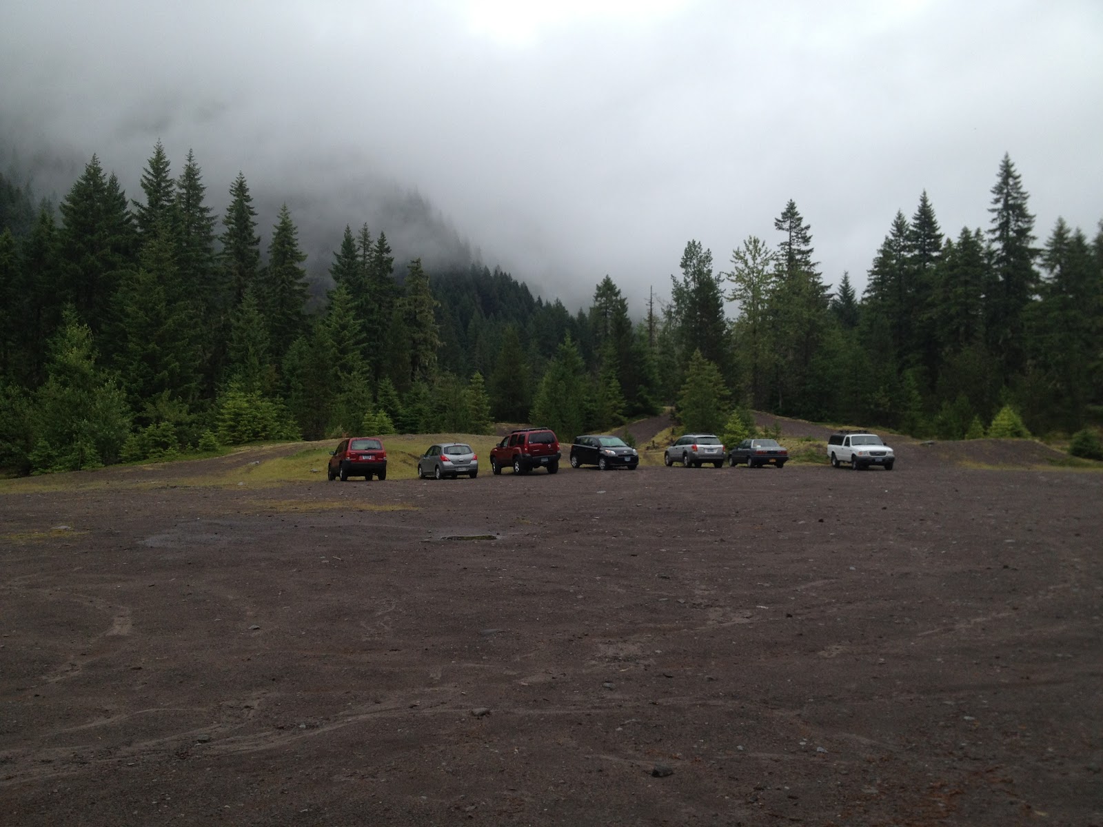

We got there pretty early (which means by 10am or so, since it's quite a drive from west Portland) and weren't sure we were in the right place. All of the references we looked at talked about how popular the spot was and how to find extra parking spots if the area was full. As you can see, we didn't have any problems. Maybe it was the weather, but honestly this doesn't seem like a place to decide to go on a whim. You have to plan for this hike to a certain extent, so while weather could be a factor I find it hard to believe people wake up on a nice day and just decide to head out here on a whim. This meant the trail wouldn't be busy though, so we liked that.


The trail follows the Sandy River for a while on a moderate slope. The landscape is pretty in the way nature's power can be pretty; this entire area was overrun with flooding just a couple years ago, washing out homes and roads, and the evidence of that destruction is everywhere.


After while you get to a bridge across the small but powerful river. There is no handrail and the "bridge" is narrow, only a few feet over the rushing water. Misaki surprised us both by jumping right up and walking across like it was no big deal. Honestly, I thought I might have to carry her. That's our pup - always keeping us on our toes.


The trail twists and turns through the forest and moss-covered rocks and dead trees cover the landscape. It's pretty, with every shade of green you can possibly imagine.


Then the uphill rise begins and it seems like it's never going to end. The rise isn't at any time too steep, it's just  constant. At times the river side of the narrow trail is basically far drop to the water and I was keeping a close watch on Misaki, although if anyone was going to slip it was probably me and not the dog.

She likes to freak us out, too. After Wifey and I spent some time talking about how easily you could just disappear out here - and my writer mind started down the path of a horror story - Misaki stopped at one point, staring into the woods. She even barked once, like there was something out there. Wifey and I looked as best as our weak human eyes could manage, but we have no idea what she saw. Bear? Cougar? No idea.

After the major climbs in the trail it switches back a few times through the woods, away from the river. The sound of rushing water teases you, getting louder and louder as you continue. Then, seemingly without warning, you step around a corner and you see this. (Please, click again on the picture. It's impossible to do this justice, but make it as big as you can.)


There she is, Ramona Falls in all her glory. You really have to spend some time here in order to get a true feeling for how magnificent this waterfall is, to see it from all the angles. And check out this bridge crossing the creek flowing from the waterfall.


Given how far from car access you are it's obvious it's built from the area's trees by necessity. It's very, very sturdy. I'd hate to have had to carry the chainsaw all the way in to build this with.

We had our lunch here, which consists of standing around and holding your food because, well, you are in the middle of the forest and there is no seating. It's also really loud, so it's not really the place to linger for a conversation or hang out with a book, so it's time to get back on the trail. You have two choices. You can either turn around and go back the way you came, or continue on down the path, which will eventually go far, far away or loop back to the trail you came in on near where you crossed the river (your choice).


We elected to try out the loop. This follows Ramona Creek all the way to the Sandy River. At points it runs along a gigantic rock wall that seems to just appear out of nowhere and is riddled with thin waterfalls. We crossed back and forth across the creek a few times, once on this magnificent bridge. This one seemed to be brand new.


To the right of it was an old one, battered and broken from many winters and floods.


We followed this trail for awhile and eventually reached the Sandy River, but not where we could actually cross it. Apparently we missed a turn. However, at this exact point were a few people crossing the river on a fallen tree. That didn't look safe at all but they didn't seem to be in any trouble. We turned back and apparently those people made it just fine, because we never saw anything on the news about missing hikers on Mt. Hood. At least not that week.

After we turned around we walked a short distance and ran into this written in the dirt and pine needles on the ground.


How handy! Apparently we weren't the only ones who missed a turn.

On the way back, after we crossed the same bridge over the Sandy River, we came upon some moss-covered boulders the size of a car. I picked up our cute little pup and put her up on top of the boulder, about six feet off the ground. I wasn't sure what she would do, but she seemed pretty pleased with her perch above her human servants. She calmly sat down on the rock, looking down at us as it to say, "Finally you know your place." We had to take some pictures and this one might be my favorite of her ever.


Misaki continues to amaze me. By the time we got back to the parking lot Wifey and I were dragging. That hike was exhausting, testing not only muscles but stamina. Despite packing plenty of food and water we just wanted to collapse on a couch. But Misaki? Not her. I swear she got stronger and stronger, picking up the pace the more miles we put behind us. We usually let her set the pace anyway, since it's faster than what we might set on our own (we joke that she's our trainer, pushing us more than we would push ourselves, and give her credit for keeping us in line), but we almost never see her out of breath.

After over seven miles of hiking, 1,000 feet up and down, she was in the parking lot with a great big grin on her face, wondering where we were going next. I should also point out that she's nine years old, which is something around 60 in dog years. I hope like hell when I'm 60 I'm in at least half as good of shape as Misaki is now.

Portlanders, get out of the city and check out this waterfall because it's not to be missed. Bring your dog, too, but as always, Misaki prefers it if your dog is on leash as she always is.

12/16/2012

Touch Portland's Water!

I was born in Portland, raised in Portland, lived my whole life in the Portland area (apart from my time at the University of Oregon), but I had never been to Mount Tabor Park until this past summer. Considering it dominates the landscape of the southeastern part of the city, that's quite an accomplishment.

Mount Tabor is not a mountain; it's a long dormant cinder cone, a relic of a volcanic eruption centuries ago, and named after a city in Israel. The park has hiking trails, tennis courts, basketball courts, picnic areas and fantastic vistas in all directions as one of Portland's highest points. When I was growing up it wasn't exactly known as very family friendly (probably why I had never been there), but these days - at least during daylight - families gather, lovers walk hand-in-hand and dogs are exercised by the dozens on the city's nicest days.

Also, the park is home to many of the reservoirs supplying drinking water to the City of Portland.


To me, it's a little odd. I mean, a person can literally walk right up to the reservoir (at the fence in the above picture), put their hand through the bars, and do whatever they want. Sure, the water is filtered and purified somewhere between these large pools and your faucet, but still.


And, as you can clearly see, they are completely open to weather and wildlife.


They do provide a nice backdrop for pictures. Even Misaki was impressed.

And yes, there are serious repercussions if anyone is caught messing with the pools. Presumably there is video surveillance as well.


Personally, I think there could be a little more prevention in place. These fences could be further back from the edge of the water, for one.


But hey, that's just me. The water at our house does not come from the City of Portland, but presumably it works out for them.

One of the reservoirs was empty because it was being cleaned and having some repairs done. These pictures do a poor job of really providing reference points for size - they are truly gigantic. Bigger in length and width than a football field, that iron fence is about eight feet high. You can also see the normal water line in this picture below, a few feet below the fence.


Here's a pic attempting to get the entire space. Doesn't that look like something you want to drink out of?


Drinking water aside, the park is a lot of fun and good exercise for people and their canines. And while the park is a fairly steep hill, the trails have been created so people can casually wind their way in circles to the top.

Or, if you are like us, you can simply take the stairs straight up.


The view from the top of the park probably isn't as good as it was 30-40 years ago because the evergreens continue to grow (not that I want to stand in their way). Still, on a nice day, a Shiba can see for miles. So can her humans.


It's a great place for a some exercise and we've been back a couple times since our initial visit.

Pro tips:

On nice days get there early. The parking lot fills up by noon.

Bring sunscreen on nice days because while there are plenty of trees all of the trails near the reservoirs are in open spaces.

Dogs on leash only. As it should be.

There are plenty of restaurants in the area to grab a bite. At the northeast corner of the park is Misaki's favorite, Steve's Cheese. At the east side is all the restaurants on Hawthorne. To the west side is The Country Cat for all meals, Bi-Partisan Cafe for coffee, pie and snacks, and Tanuki for dinner.

8/17/2012

Hiking Mirror Lake

Mirror Lake is one of those places we've driven by many, many times but never stopped at, usually for good reason because we are on our way to somewhere else.

We were missing out.

The access to the trail is just after civilization ends on Highway 26 east of Portland. The highway says goodbye to Welches, narrows to two lanes, and heads through some forest before widening to four lanes again and starting towards Government Camp. Off to the right the land drops steeply into a valley for awhile, but then you go around a curve and suddenly that same side of the street has a steep hill. Usually here you will see a mess of cars parked with no real signs - this is where you park to head to Mirror Lake.

This hike is a little over three miles round trip and is generally referred to as "easy." To be honest, calling this easy is a bunch of crap. Easy is walking on flat sidewalks. This hike involves steep hills and uneven surfaces, so to call it anything less than moderate is plain wrong.

Most of the hike is uphill over a myriad of switchbacks, crossing a creek or two on narrow bridges, over ground riddled with stumps and rocks. Going up the terrain isn't a big deal, but going down following a crazy little Shiba named Misaki who apparently would rather run it's kind of dangerous. Be careful! (As always, click the pictures to see larger versions.)

One example of a switchback.

I wanted to get a picture down the hill, but the trees were too dense and they didn't really turn out.

There is a rock slide that the trail switches back and forth across about three or four times on the way; Misaki was quite pleased with herself for conquering the boulders.

Misaki is quite proud of herself.

Here's a pic of one of the bridges, this one just before the trail splits to go around the lake. Misaki continues to amaze me at how fearless she is. The creek rushed underneath, but she took a measure of what it would take to hop onto the narrow bridge and just did it. Most dogs, especially smaller ones, would hesitate, but not her.

Fearless pup.

Guess who was the first one to see the lake?

Zen.

And what did she see, a little over a mile and a half into our hike? It's breathtaking, really. They don't call it Mirror Lake for nothin'.

No words.

Wifey and I had packed a lunch, so we sat on the rocks at the water's edge. We tried to enjoy the quiet, but it was shattered by a bunch of out of control kids with no sense of personal space.

One interesting note: You can make this a longer hike. Turning away from Mt. Hood, if you look up to the right there is a ridge - Tom Dick and Harry Mountain (really) - far into the distance (another four miles each way, I think). Someday, when I'm better prepared, that would be a fun (you know, if by fun I mean exhausting, mentally draining, and likely to induce massive hamstring cramps) hike to do. I can just imagine the amazing pictures one could take.

We had some chipmunks hang out with us for lunch, as well as this little guy and some birds we'd never seen before.

Our dining companion.

Misaki generally leaves the wildlife alone, but I was wondering if maybe she was going to go after some of the fish darting around in the shallows.

Looking for noms.

We had a great time. It's a great workout (moderate, not easy - I want to see their definition of easy) and not too far away. However, get their early, especially on a nice day on the weekend because that parking area can fill up and you don't want to be forced to park on the very edge of Highway 26 as cars fly by at 60+ miles an hour.

It's worth the effort, especially when you see something like this.


8/06/2010

Summer at Trillium Lake

A few months back Wifey and I picked up a new sport, going snowshoeing for the first time at Trillium Lake on Mt. Hood. This was in January, were the lake is covered with snow and ice, you park at the sno-park just off Highway 26, and then you hike two miles to the water.

At the time, between swearing about how this was insane and never again, we did agree we wanted to come back in the summer, when the day was clear and we could hike around the lake. Last Saturday was that day. (As always, click the picture for a bigger version.)


It's quite possible this is the most picturesque place in the state (or is it Crater Lake?), which given all the natual beauty in Oregon would be saying a lot. Still, check out that mountain reflected on the water... Perhaps it would be even better with more snow on it, or if the grayer small clouds were gone, but in my mind it's pretty damn fabulous.

It was also nice the lake wasn't overly busy. Sure, there were plenty of people near the dam and the campground was full, but I don't think I could actually call it "crowded."

And what would a trip to Trillium Lake be if I didn't take pictures of trilliums? Since it was July they weren't in bloom - maybe next spring we'll have to go there in early May, as soon as cars can drive to the lake, and catch some trilliums in bloom. (Hmm...these may not be trilliums - see the comments. What are they?)


Without a doubt there are more trilliums here in one place than I have ever seen in my life.

The trail winds around the lake, about two miles total. We did not walk all the way around because about a third of the way around we saw a sign about construction on the dam leaving that part closed, so we walked halfway and then back. Of course, when we came to the dam from the other side, there was no construction at all. (A later sign said the dam was closed Sun-Thurs.)

The lake is to the right in this picture, with the mountain behind us. The trail is well maintained as you can tell.


There is an amphitheater just past the campground. If you look close you can see I caught Misaki in mid jump, which is pretty amazing because she almost never does anything like this. I was just taking the picture and she's putting on a show.


As far as local wildlife goes, there were a ton of these brilliant, electric blue dragonflies. The usually didn't sit still for too long, but I caught this one.


I love this picture of the cloud on the south side of the mountain. This is just about looking straight towards Timberline, and the shadows of the clouds on the mountainside are very cool.


This is the opposite side of the lake from the dam. It's a marshy area, but there were still kayakers able to skim through it.


This is a panorama shot from the dam (the left side of the picture). Right after this we saw an eagle (we think it was an eagle) dive down into the water and grab a fish, then fly off - that was amazing. Earlier we also saw a bald eagle, but this was a different kind. It was much bigger than a hawk or a falcon, but again, not sure exactly what it was.


Here is Misaki and Wifey posing at a boat ramp. This is about mid-morning and you can see not all the low clouds had burned off


MISAKI'S VIEW

Here's a few pics taken from various points around the lake are Misaki level.

This first one is near the amphitheater, looking across the lake.


Here is Misaki at the boat ramp checking out the local color. She actually walked in to the freezing water to get closer to the duck, but after a few moments decided the female mallard wasn't worth it.


How's this for some perspective?!


Misaki wouldn't sit in one spot long enough for me to really focus a shot from her ears towards Mt. Hood, so this is the best I could do. Imagine you are on a boat.


Fun times - we'll definitely have to go back and do the full hike.

5/18/2010

Hiking Falls Creek Falls

Just a few miles east of the Portland area there is a waterfall that could be the most spectacular in the entire Columbia River Gorge area. No, I'm not talking about that over-touristed Multnomah Falls, but something much, much better.

Falls Creek Falls is in Washington, just a little northeast of Stevenson. To get there from Portland take Interstate 84 east to Cascade Locks and take the Bridge of the Gods ($1 toll each way) over the Columbia River to SR-14 in Washington. Head east, towards Stevenson. Drive through the small town and a few miles past that you will see signs for Carson. Take a left onto Falls Creek Highway and Carson. Drive through the town and head north to about milepost 19 where there will be sign to the right for Falls Creek Falls. Take the gravel road (watch for pot holes!) about a mile or so into the forest to a small parking lot. There is room there for 6-8 cars comfortably, though this day we went there were 15 that had found spots. A Northwest Forest Pass is required for this area, either an annual or day pass, and you cannot buy them here - you must bring it with you. There are also no restrooms or any other kind of facilities - you have what you bring, and please take it all out with you.

The hike begins with Falls Creek to your right on a relatively moderate slope through deep woods. After not too long you cross over the creek on a bridge and the rest of the hike has the creek on your right as the trail winds up and up. And up. And up. The trail is plenty wide so people can pass single-file going opposite directions.

Along the way you get nice views like this:

Falls Creek

Now, I would suggest being careful when you take in the views. My ankle says it's best to stop moving before you look around, since there are plenty of rocks and roots jutting from the dirt trail. If you fail to not look at the ground you are crossing, the risk is real of tripping, spraining an ankle, and falling on your face.

Not that I would know or anything. Maybe. I mean, the purple pool at the bottom of my right foot is just about gone, so it may as well have never happened. Right?

I have to say, we've done this hike twice before and I had forgotten how hard it is. It's really a lot of uphill - even the dog was tired. It's 1.7 miles from the parking area to the waterfall, and most of that is uphill over this semi-rough terrain. We have a book about hiking in the Portland area (60 Hikes Within 60 Miles, I think it is) and the description for Falls Creek Falls is "easy" - umm...duly noted. Anything in there marked "difficult" I'm pretty sure we aren't quite ready for. Yikes.

Of course, hiking on a sprained ankle doesn't make it much easier, but thankfully it didn't swell all that much. Just hurt like hell.

There is a point not too far from the end where the trail crosses over another feeder stream of the creek. Lush mosses cover the rocks in the water, both uphill and down, and it's really one of those spots where you think hey, I could hang out here for awhile. In fact, on the way down we passed a group of people so taken with it they asked us if the waterfall at the end was worth going on. 


Up the stream.

Oh yes, yes it is. If you turn around here and then see pictures of what you missed you will kick yourself because you will have to go back. And starting over means doing the whole damn hill over again, and no one wants to do that.

As we worked our way towards the top of the trail, our stops became more frequent. Even Misaki asked to stop and catch her breath a couple times. We had to cross a thin stream without the benefit of a bridge and she was not having that - I had to pick her up and set her down close to across, all the while trying not to fall down the hill on my bad ankle myself.

Yes, she is spoiled - why do you ask?

Small dogs may not like this.

The closer one gets to the end of the trail the louder it gets. The crashing of the waterfall is enough to take a tired body the last few feet and when you crest the trail and see the waterfall, every drop of sweat is worth it (click on the picture for a bigger version).


Falls Creek Falls

The trail leaves you about even with the top of the final piece of the falls, but there are actually multiple tiers. This picture doesn't do it justice - a top to bottom panorama might have been better (maybe next time) - there is another piece to the waterfall even higher up. I couldn't guess as to the height of the falls from top to bottom, but in my mind it's much more impressive than the much more famous Multnomah, but since it's not nearly as easy to get to it will never be as popular. Which is fine with us.

We took a lunch and nibbled as we watched the water crashing down the rocks. Despite the roar the sound was pretty relaxing, and despite the sweat and sprained ankle I'd do this trail again in a heartbeat. Well, after the ankle heals of course.

The walk back is much faster as downhills usually are, but because of how steep the trail is and all the rocks and roots, calling it much easier would be misleading.


Misaki Approved!

This is a great trail for dogs. We saw plenty on the hike, both on and off leash (Misaki is a bigger fan of the ones on leash). Definitely pack in water and treats for them at the falls, because it's a tough run. It's a little tougher for smaller dogs because of having to cross that stream - later in the season it won't be an issue, because it will be dry - and Misaki did have to jump over a couple fallen trees on the trail. On the way up she wasn't quite sure about how to approach them and needed some coaxing, but on the way down she just hopped over them like it was nothing. As we struggled a tad more to get over them, she'd look back at us like, "What the hell is taking you guys so long?!"

Of course, when we got home, who was the one who collapsed on the floor, only to get up for dinner before collapsing again? Well, besides me, it was the dog.

I think she's looking forward to the next adventure.

1/12/2010

Picking Up A New Sport

Wifey and I decided to take up a new sport over the weekend: snowshoeing. It's something we've been thinking about trying for a couple years but just never really got around to doing it. It seemed to make sense we would enjoy it, since we like hiking and the outdoors (as long as we can figure out how to get home).

A few things had held us (or, more accurately, me) back:

1 - Driving in the snow. I hate having to deal with it, and I have no chains. Thankfully this past weekend the roads up to Mt. Hood were perfectly clear. I have a feeling I will be buying chains here at some point though, just in case.

2 - The right clothes. For some reason we just never really had clothes fit for snow and cold temperatures. Part of that is having waterproof stuff. I bought my first pair of waterproof hiking boots in my life this past year. That's kind of key for walking in snow for extended amounts of time. Sure, I live in a place where it rains a lot, but I don't spend time outside in the rain - and definitely not extended time. The rain doesn't necessarily bother me, but who wants to do that? Plus, we don't ski or snowboard, so it was never really a need.

3 - Literally having no idea what we are doing. I mean, it's just hiking in the snow with tennis rackets on your feet, right? How hard can it be? Me, though, I like some kind of training when it comes to a new sport - I'm not one to just throw myself into the deep end.

Well, a couple weeks ago REI came through for us. They had a free seminar at the one closest to our house about getting ready for snowshoeing where they promised to talk through the gear, clothing, where to go - things like that. Since you can't beat free and we shop at and respect REI, we decided to go, even though it was after a hellish 1.5 hour workout courtesy of Jillian Michaels and her training books (that's another post).

The seminar was informative, but honestly I'm glad we didn't pay for it. It was all pretty logical: dress warm but know you will sweat (it's a heck of a workout), dress waterproof, snowshoes are pretty straightforward as to types and how to use them, stay out of the cross country skiing lines, pack food and water - you know, all the things you would do for hiking, except recognizing it's cold and wet.

It also turned out REI was having a rental special last weekend for $5 instead of $20, but despite the price were pretty sure this was something we would not only enjoy once but over and over. So what the hell - we each bought a set from Atlas that came with poles and a bag - plus a one-day Sno-Park pass so we could legally use it. The seminar gave some ideas on places good for beginners, so we chose Trillium Lake.

Sunday was a nice drive up Highway 26 to the Government Camp area. Dry roads, not too much traffic. I think we ended up pulling into the sno-park lot at just before 11, probably setting off down the hill towards the lake just after 11 after getting ourselves situated with layers and into our snowshoes.

The person at REI told us that if you can walk, you can snowshoe. For the most part that's pretty much true, but it did take some time to get used to the wider strides. Our hike started off with a 200-foot downgrade, so that didn't make it the easiest beginning, but we got the hang of it. (By the way - waterproof hiking shoes are an absolute must. Without those snowshoeing would be miserable.)

We took our time, getting mostly passed by people who had obviously done this before and were in better shape, but we made good time. It's about two miles to the lake from the parking lot, with some up and down after the initial descent - all of the rises and falls are smooth though, nothing too steep.


View Down/Up the Trail


There was one weird thing. We were walking towards the lake, about a quarter mile in, and noticed red spots in the snow. It was pretty evident it was blood, but it took us a bit to realize it was in a pattern. What it looked like is a dog - and there were plenty on the trail, so we won't be bringing Ruby - had some kind of cut on it's paw. Closer inspection of the pattern made it clear. Poor pups - he must have cut himself on something or it's also possible something split in his paw because of the cold. Hopefully his owner got that fixed up.

It took us about a little over an hour to get to the lake with frequent breaks. It was pretty busy, with people going both ways on snowshoes, cross country skis, and even just on foot. Well, busy, but it's not like it was cramped or anything like that. Thankfully also the bathroom at the lake was open (literally - the door didn't close, which was fun...or something). We had our lunch there and took some pictures, while also dodging a loud raven. (At least, someone said it was a raven. I have no idea, I just know it didn't sound like a crow.)


The Raven


Unfortunately the top of Mt. Hood was firmly stuck in the clouds when we go there, so all of our pictures show a topless mountain. Who knows, maybe some people are into that.


The Famous Wy'East


View From the Dam


About the time we started our trek back the sun started to come out, which gave us a nice picture of sun rays on the frozen lake. (If you go, please know, it will NOT support your weight. No, I didn't try it.)


Welcome Sunshine!


This was nice - when we got back to the parking lot all the clouds from around the mountain were gone. Oh well.


Beginning of Lonely Trek Back


Speaking of that hike back - it was long. Well, it probably wasn't longer than the hike out, but we were getting tired because apparently a five-mile trek is a bit much for your first time. Also, there was much more uphill - especially the last quarter mile or so - and you know what happens when you are snowswhoeing and you get tired? You don't pick up your feet enough and the crampons on your toes get stuck in the snow when you try and walk. Thankfully neither of us fell, but I came close a couple times.


Mt. Hood - Late Afternoon From the Sno-Park


Overall, it was fun - we just should have gone a shorter distance for the first time out. Both of us ended up with a blister or two on our feet because our shoes were too loose. Not loose in the snowshoe, but our physical foot inside the hiking boot. I think both of us would like to look around for better socks that help fill the shoe, or perhaps maybe even actual snow boots of some kind. We also need new waterproof pants. We both had Columbia waterproof shells we've had for a few years - mine was a tad on the large side. (I mean, yay for me it's too big, but having to stop and pull up my pants every 100 yards was kind of annoying.)

About the only bad thing that happened all day was my sno-park pass apparently glued itself to the inside of my windshield. Now I have to figure out how to clean that off.

Trillium Lake was beautiful. We'll probably go back there sometime on snowshoes, maybe even hike around the lake a bit, but we will definitely go back in the summer. You know, when you can drive that two miles to the around-the-lake trail instead of wearing yourself out getting there. There are also lots of side trails that looked intriguing, but we agreed it's best to check those things out in summer rather than winter. At some point I probably want a GPS too (if you have a suggestion, please leave a comment - much appreciated!).


A View Like This Made It Worth It


Good times - can't wait to go again!